Introducing Agribound: Unified Field Boundary Delineation from Satellite Imagery
We are excited to announce the public release of agribound, a Python package that unifies seven complementary approaches to agricultural field boundary delineation into a single, reproducible pipeline. Whether you are working with 1 m NAIP imagery over U.S. croplands or 10 m Sentinel-2 composites anywhere in the world, agribound lets you go from raw satellite data to clean, vectorized field boundary polygons in a single function call.
The Problem
Agricultural field boundary delineation is essential for crop monitoring, yield estimation, water resource management, and precision agriculture. However, the landscape of available tools and models is fragmented:
- Object detection approaches (YOLO-based) are fast but may miss irregular shapes.
- Semantic segmentation models (FTW, UNet) generalize well but require post-processing to extract individual field instances.
- Foundation models (DINOv3, Prithvi-EO-2.0) offer powerful learned representations but need fine-tuning for best results.
- Embedding-based methods (Google Satellite Embeddings, TESSERA) enable unsupervised delineation without any labeled data but require clustering and refinement.
Each approach has its own data format expectations, preprocessing requirements, and output conventions. Researchers and practitioners end up maintaining dozens of ad hoc scripts to stitch these workflows together.
What Agribound Provides
Agribound wraps all of these into a unified pipeline:
Satellite composite --> [Optional fine-tuning] --> Delineation engine --> Post-processing --> LULC crop filter --> Export
A minimal example:
import agribound

gdf = agribound.delineate(
    study_area="fields.geojson",
    source="sentinel2",
    year=2024,
    engine="delineate-anything",
    gee_project="my-gee-project",
)
This single call handles GEE authentication, cloud-free composite generation, engine inference, polygon smoothing and simplification, LULC-based non-agricultural polygon removal, and export to a GeoDataFrame with area, perimeter, and provenance metadata.
Seven Delineation Engines
| Engine | Approach | GPU Required |
|---|---|---|
| Delineate-Anything | YOLO instance segmentation | Recommended |
| Fields of The World (FTW) | Semantic segmentation (14+ models) | Yes |
| GeoAI Field Boundary | Mask R-CNN | No |
| DINOv3 | Satellite-pretrained ViT + DPT head | Yes |
| Prithvi-EO-2.0 | NASA/IBM ViT foundation model | Recommended |
| Embedding | Unsupervised clustering | No |
| Ensemble | Multi-engine consensus | Depends |
Nine Satellite Sources
Agribound supports Landsat, Sentinel-2, HLS, NAIP, USGS NAIP Plus, SPOT 6/7, local GeoTIFFs, and pre-computed embedding datasets (Google Satellite Embeddings, TESSERA) -- all through a consistent interface. The USGS NAIP Plus source provides the same NAIP imagery available on GEE but acquired directly from the USGS USGSNAIPPlus ImageServer, enabling high-resolution field delineation without GEE authentication.
Automatic LULC Crop Filtering
A key differentiator: unlike other tools that detect all visual boundaries (including roads, water bodies, forests, and buildings), agribound automatically removes non-agricultural polygons using the best available LULC dataset for your study area:
- CONUS: USGS NLCD (1985--2024, 30 m)
- Global (2015+): Google Dynamic World (10 m)
- Global (pre-2015): Copernicus C3S Land Cover (300 m)
This is enabled by default and requires no configuration.
Example Results
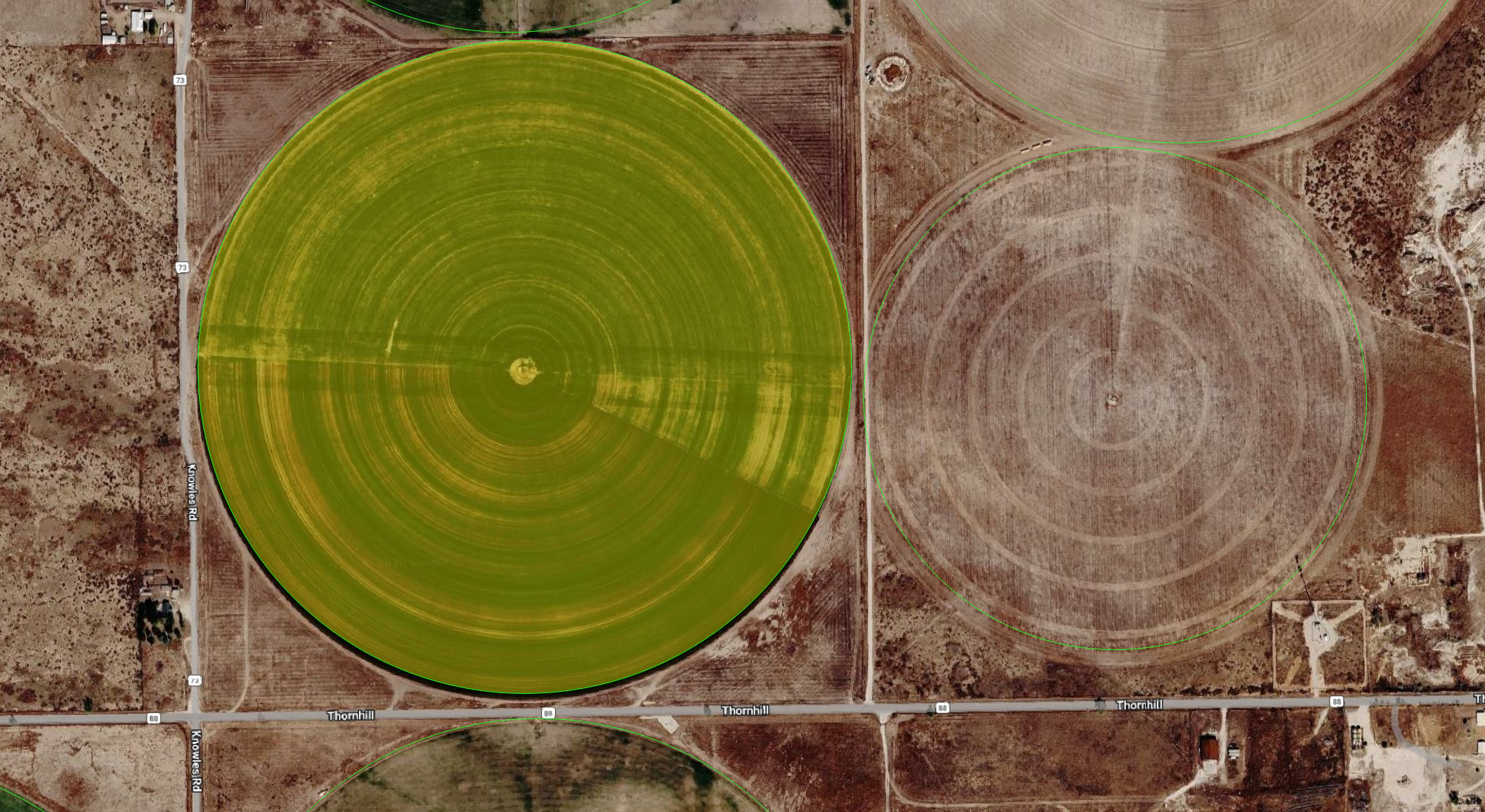
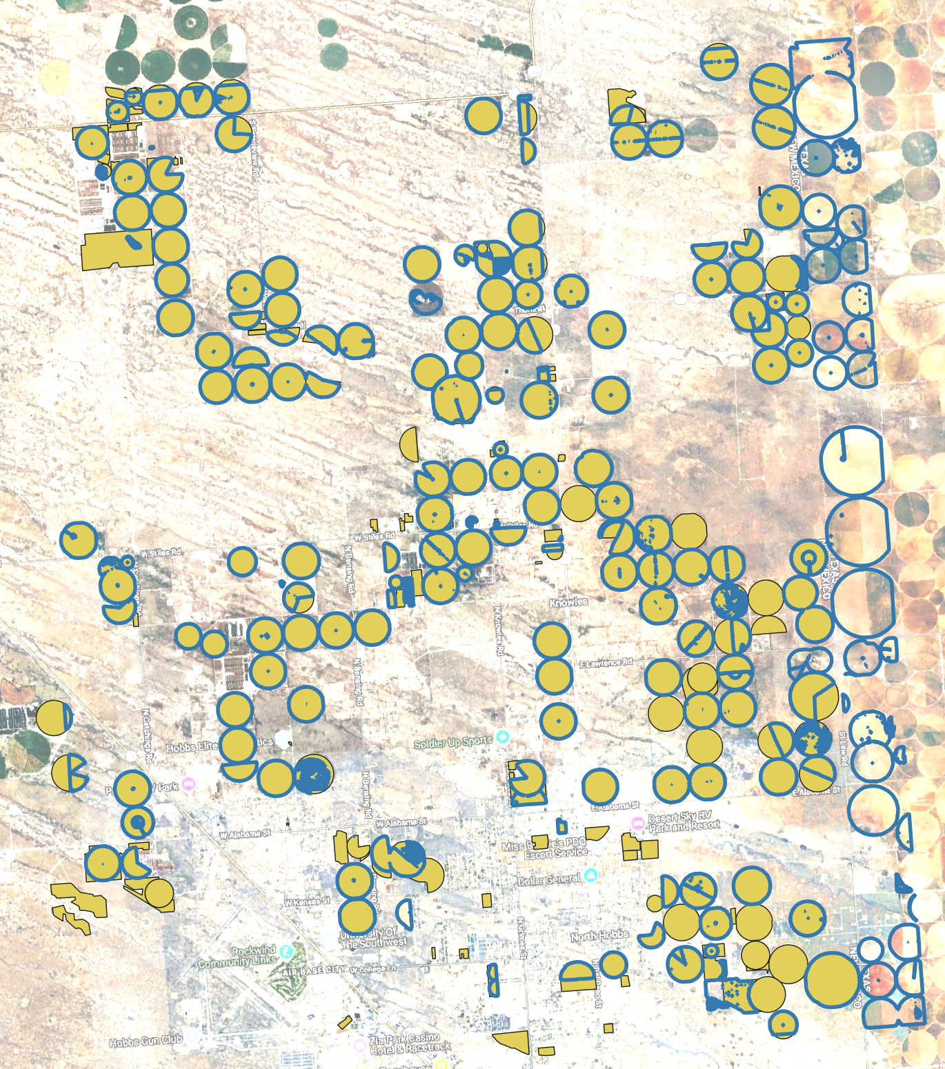
Supervised: DINOv3 + SAM2 on NAIP (New Mexico, USA)
DINOv3 fine-tuned on NMOSE reference boundaries with LULC filtering and SAM2 per-field refinement on 1 m NAIP imagery. The resulting boundary linework approaches the quality of manual human digitization:
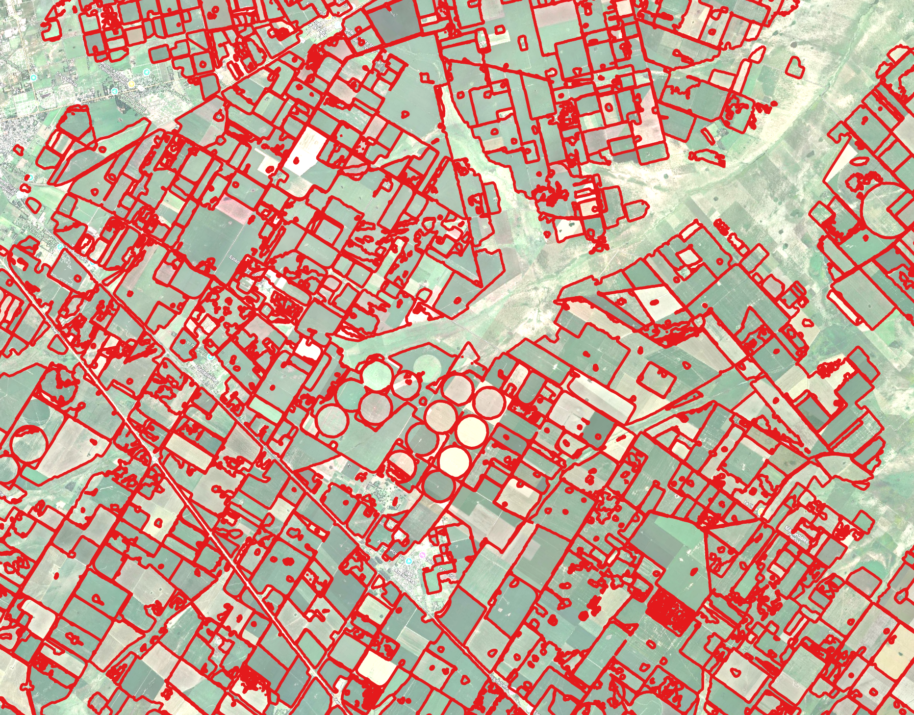
Unsupervised: TESSERA + LULC + SAM2 (Pampas, Argentina)
Fully automated -- no training data, no reference boundaries. TESSERA embedding clustering with Dynamic World crop filtering and SAM2 refinement:
Getting Started
Install agribound:
For GPU engines and GEE support:
Check out the Quickstart tutorial for a complete walkthrough, or browse the Gallery for results across nine regions, five satellites, and all engines.
Community Recognition
Agribound was highlighted by the TESSERA team at the University of Cambridge's Centre for Earth Observation for its integration of TESSERA embeddings into an end-to-end field boundary delineation pipeline.
The launch announcement on LinkedIn received over 500 reactions and 55 reposts from the geospatial and remote sensing community within two days of its release.
First Community Contribution
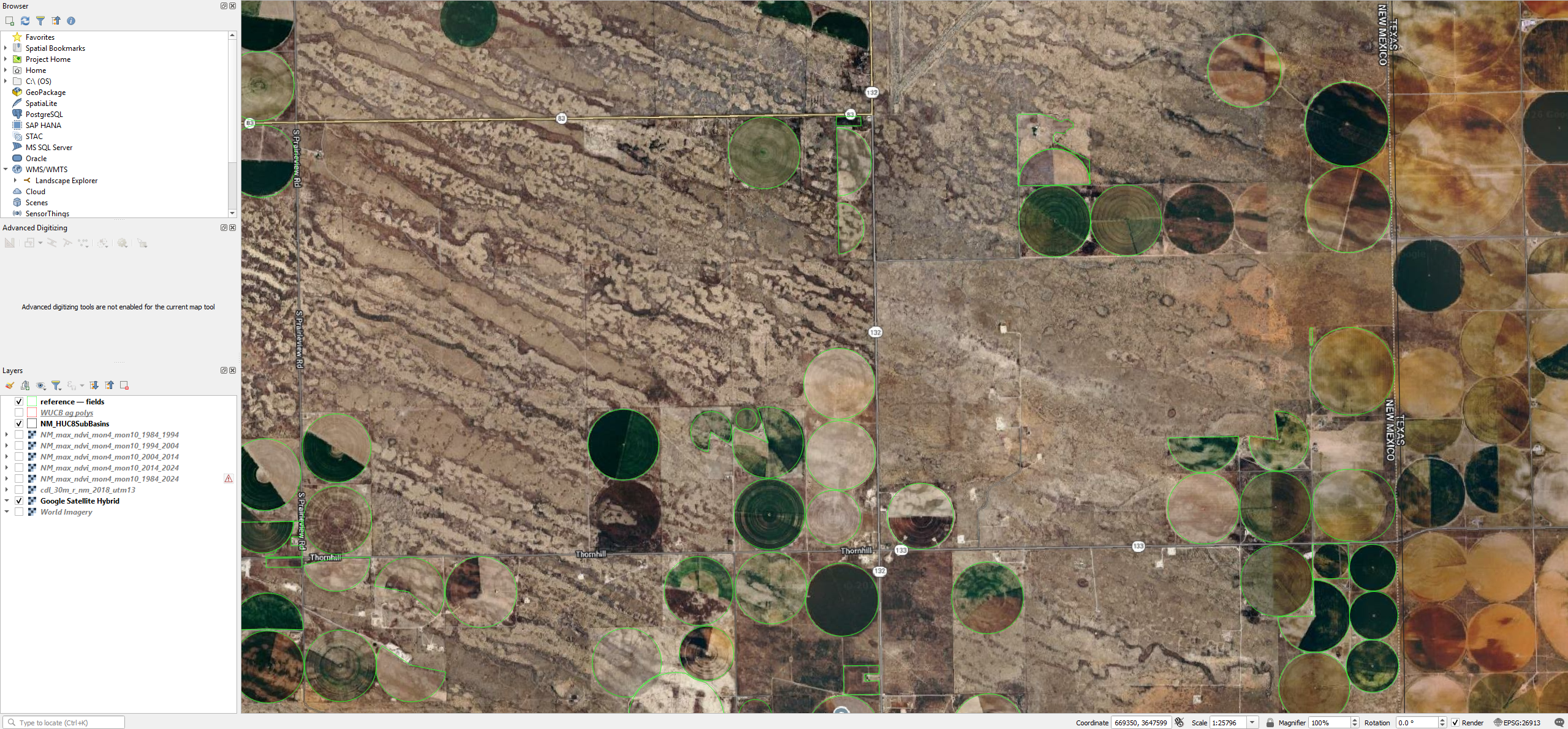
We are thrilled to highlight agribound's first community contribution from Jeremy Rapp at the Department of Earth and Environmental Sciences, Michigan State University. Jeremy contributed Example 16, which adds support for the USGS NAIP Plus ImageServer -- the same NAIP imagery available on GEE but acquired directly from the USGS USGSNAIPPlus ImageServer -- as a non-GEE high-resolution imagery source.
This example demonstrates agribound's local-raster acquisition path: the AOI is queried directly from the USGS ImageServer, exported to a local GeoTIFF, and then passed into the Delineate-Anything engine pipeline -- all without requiring Google Earth Engine authentication. This is a significant addition for users who want to work with 1 m NAIP imagery but do not have GEE access or prefer a purely local workflow.
Jeremy's contribution showcases exactly the kind of community-driven extension we hoped agribound would enable: identifying a new data source, integrating it into the existing pipeline, and providing a complete working example. Thank you, Jeremy, for this excellent contribution!
What's Next
- A paper submission to Remote Sensing of Environment is in preparation.
- We are expanding engine support and adding new embedding datasets as they become available.
- Community contributions are welcome -- see the Contributing guide.
Citation
If you find agribound useful, please cite:
Majumdar, S., Rapp, J., Huntington, J. L., ReVelle, P., Nozari, S., Smith, R. G., Hasan, M. F., Bromley, M., Atkin, J., Jensen, E. R., Ketchum, D., & Roy, S. (2026). Agribound: Unified agricultural field boundary delineation from satellite imagery using geospatial foundation models, pre-trained segmentation, and embeddings [Software]. Zenodo. https://doi.org/10.5281/zenodo.19229665
Majumdar, S., Rapp, J., Huntington, J. L., ReVelle, P., Nozari, S., Smith, R. G., Hasan, M. F., Bromley, M., Atkin, J., Jensen, E. R., Ketchum, D., & Roy, S. (2026). Toward unified agricultural field boundary delineation: An open-source, cloud-native framework integrating geospatial foundation models, satellite embeddings, and pre-trained segmentation. In prep. for Remote Sensing of Environment.
Give the repo a star if you find it useful!